Collective Kel-Elemi Republic: Difference between revisions
fandom>Peef-silt No edit summary |
fandom>Peef-silt |
||
| Line 6: | Line 6: | ||
== Geography == | == Geography == | ||
The Collective Kel-Elemi Republic is made up of three islands, Keral Island, Corralith Island and Annanela Island, of which Annanela Island is the largest and Keral Island is the smallest | The Collective Kel-Elemi Republic is made up of three islands, Keral Island, Corralith Island and Annanela Island, of which Annanela Island is the largest and Keral Island is the smallest. Corralith Island is separated from Annanela Island by the Crooked Channel. | ||
On Annanela | On Annanela Island there are 3 rivers, the largest of which is Kelania River. All three originate from the Eluti Mountain Range in the center of the island- These mountains are the highest elevation land in the Collective Republic and the largest mountains overall. These mountains are surrounded by the Haalki Forest, a vast tropical jungle which contains much of the island and the nation’s resources. It also has Aschemal Bay to the south and Uzhbere Bay to the east, both large centers of fishing. | ||
On Corralith Island there are large mountains. These are the Qaadi Mountains which are rich in minerals. There are multiple bridges connecting Corralith with Annanela. On Keral Island there is mostly grassland with a small jungle in the center. There are coal deposits on the island. | On Corralith Island there are large mountains. These are the Qaadi Mountains which are rich in minerals. There are multiple bridges connecting Corralith with Annanela. On Keral Island there is mostly grassland with a small jungle in the center. There are coal deposits on the island. | ||
Revision as of 01:30, 12 March 2023


The Collective Kel-Elemi Republic is a nation consisting of three islands in the southeast of the Attu Archipelago. The Collective Kel-Elemi Republic is made up of Keral Island, Corralith Island and Annanela Island, of which Annanela Island is the largest and Keral Island is the smallest.
Its current ruler is President Robert Grayson.
Geography
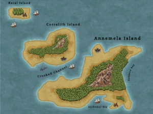
The Collective Kel-Elemi Republic is made up of three islands, Keral Island, Corralith Island and Annanela Island, of which Annanela Island is the largest and Keral Island is the smallest. Corralith Island is separated from Annanela Island by the Crooked Channel.
On Annanela Island there are 3 rivers, the largest of which is Kelania River. All three originate from the Eluti Mountain Range in the center of the island- These mountains are the highest elevation land in the Collective Republic and the largest mountains overall. These mountains are surrounded by the Haalki Forest, a vast tropical jungle which contains much of the island and the nation’s resources. It also has Aschemal Bay to the south and Uzhbere Bay to the east, both large centers of fishing.
On Corralith Island there are large mountains. These are the Qaadi Mountains which are rich in minerals. There are multiple bridges connecting Corralith with Annanela. On Keral Island there is mostly grassland with a small jungle in the center. There are coal deposits on the island.
The climate of the Collective Kel-Elemi Republic is tropical. In the coastal areas it is mostly wetlands and grasslands, however on all three islands there are dense tropical rainforests further inland. The largest of these is the Haalki Forest on Annanela Island. On the Qaadi Mountains on Corralith Island and Eluti Mountains on Annanela Island it is very wet with the highest rainfall of the regions, with monsoon level rain all year round, however it is typically colder due to its high altitude.
One main feature of the region is that it lacks much arable farmland due to heat and intense rain. Due to this, vegetables do not constitute a large portion of Kel-Elemi diets.
Every summer, there is a month-long intense monsoon that impacts the region. Annanela Island is most impacted- rainfall is so intense many vast parts of the island are overflowing with floods. As a result The Kel-Elemi have innovative flood prevention systems and an advanced water management sector which is crucial to the Kel-Elemi economy.
On the Koppen climate classification system it is mostly Af: Tropical rainforest climate and Am: Tropical monsoon climate.