Utlia
Utlia is a mountainous island in the Attu Archipelago between eee and Casea. Utlia is currently governed by the Republic of Utlia.
History
City-state Era
Earliest known settlement of Utlia comes from the Western Forests, now the Utlian Capital Territory, in these forests the first city-state is formed, known as Tela, it quickly prospers as Utlias first true civilization. Not long after, 2 more were formed nearby, the Dirn and Lesyhan, these three were all created sometime in 2750 TT. These three were the most important on the island but many smaller, less powerful ones sprouted in the north and south, of these smaller city-states, Uta and Unlaun became prominent hundreds of years later.
Unification Era
In the north the Utans annexed smaller neighbors to the east and controlled the island north of where the Balmor river flows, this group became the Eutan Kingdom on 12-11 1940 TT. The southern Unlaun annexed its neighbors and formed the Frish Kingdom on 23-6 1863 TT.
The Frishs and the Eutans were by far the most prosperous of the proto-kingdoms in Utlia, with many of the smaller city-states falling apart. The two groups had a friendly professional relationship. On 4-7 1102 TT Wynlid Liamia and Shaen eien, the kings of the Eutan Kingdom and the Frish Kingdom respectively, met at a site near the Balmor river and signed a declaration of unification, merging the two into one kingdom, known as Utlia. This moment has long been mainly attributed to Wynlid but in recent years, modern Utlian historians have began to recognize the importance of the Frishens in the agreement.
Post-Unfication
After Utlia became unified, the kingdom began to annex the nearby city-states of Tela, Dirn and Lesyhan. Tela and Dirn accepted treaties for their land in exchange for noble statuses for the ruling families. Lesyhan refused a similar treaty, leading a 8 month war which saw an Utlian victory on 1097 TT. After this war, all inhabited land on the island became owned by the Unified Monarchy.
Republic of Utlia
On 12-6 6 TT the Last King of Utlia Ywylin, who was overthrown by the RGOU, a revolutionary group led by Yyme Braia and Votan who went on to establish the Republic of Utlia.
Geography

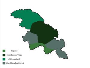
Utlia is a cold, mountainous island with a jagged coastline, on Utlia there are 4 main biomes:
- Bogland: bogs are the least common type and the least populated, the bogs of Utlia exclusively remain in the Direnomut region in the southwest of the island, these were the last parts of the island to be settled and are still the least densely populated.
- Mountain Taiga: sometimes referred to as the Lea Mountains, Utlias highest peaks and coldest areas are in this region, with year round frozen lakes and near inhospitable for humans in some of the inner sections. The tallest mountain in the eastern bloc, Mount Liamia is in this area.
- Cold Grassland: the flat prairie of the northern part of the island is where the majority of agriculture and farming happens, mainly with wheat and livestock like Brenya or Yak
- Forests: the most common part of the island, forests are generally quite hilly but not as sheer as the central mountains, these regions have the highest pop ulation density and the most diverse wildlife.
Wildlife
See: Wildlife of Utlia