List of islands by land area
Jump to navigation
Jump to search
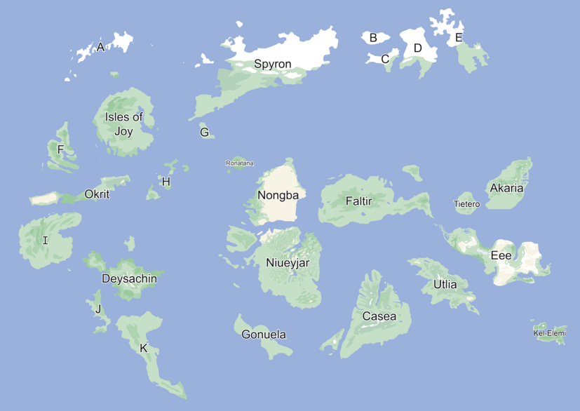
This is a list of islands in Attu ranked by surface area, population, and population density. This list groups together small archipelagos composed of islands closely related to each other. All land on the map is accounted for.
- Surface area: the number of square kilometers an island takes up when projected onto a 2d plane.
- Population: The number of people who live on an island.
- Population density: The average number of people who in a square kilometer on an island.
Map

List
| Island | Total Area | Population | Density | |
|---|---|---|---|---|
| 1 | Spyron | 26586 | ||
| 2 | Niueyjar | 20952 | 3521000 | 168 |
| 3 | Faltir | 19040 | 3740000 | 196 |
| 4 | Caseic Archipelago | 17334 | Approx. 15 million | Approx. 900 |
| 5 | Isles of Joy | 15000 | ||
| 6 | Eee | 14700 | ||
| 7 | Nongba | 12395 | 1650000 | 133 |
| 8 | I | 11860 | 0 | 0 |
| 9 | Deysachin | 8694 | ||
| 10 | Utlia | 8650 | 1400000 | 162 |
| 11 | K | 8643 | 0 | 0 |
| 12 | Akaria | 7756 | ||
| 13 | E | 5750 | 0 | 0 |
| 14 | D | 5424 | 0 | 0 |
| 15 | Okrit | 4856 | ||
| 16 | F | 4036 | 0 | 0 |
| 17 | Gonuela | 3716 | ||
| 18 | A | 2073 | 0 | 0 |
| 19 | J | 1869 | 0 | 0 |
| 20 | Tietero | 1853 | 741000 | 400 |
| 21 | Kel-Elemi | 1802 | ||
| 22 | C | 1641 | 0 | 0 |
| 23 | H | 1550 | 0 | 0 |
| 24 | B | 1280 | 0 | 0 |
| 25 | Ronatana | 881 | 45000 | 51 |
| 26 | G | 705 | 0 | 0 |